Wednesday, October 29, 2008

Gallery: New Blind Creek Trail directional signage

Sorry for the delay. I am currently studying and taking exams until November 17, so don't be alarmed, I am not going to let this blog die.

I thought I would post a gallery of the new Blind Creek Trail directional signage I spotted on a recent bike ride through Knox. When I rode on October 19, new signs had been installed between EastLink and Lewis Park (the park at the back of Knox City Shopping Centre), so hopefully more have been placed along the trail since that ride. The signage is of high quality wood, and the destinations are adequate for the trail, but could be better. I will review each sign and it's location under each of the following photos:


At the back of Knox City, with the sign telling riders there is a long and short way to Scoresby Road. Going right takes you along the actual trail while left goes along the northern border of Lewis Park. The destination of the Rail Trail helps keep the rider on the right trail.

On this note, I believe EVERY sign needs to have an arrow or arrows beside the trail name to clearly indicate which direction the official trail leads.


Same location as above, but heading the other way. Besides the lack of arrows (which I will no longer mention in this post), this sign is a good example of showing local destinations (Knox City and Stud Road) while also pointing out links to upcoming trail turn-offs.


Simple sign at the turn-off for the short track which leads to the entry to Knox City near the post office.


Now, this is where you just want to slam your head against a brick wall. First, there is no signage for the dangerous section beside Stud Road between the back of Knox City and the intersection, but the new signage has NO MENTION OF THE STUD ROAD TRAIL AT ALL!!! I wonder who was responsible for this oversight. A major trail, running along Stud Road from the Dandenong Creek Trail to George Street and from Ferntree Gully Road to Rowville. How could this not be included. But I do like the inclusion of the 2 destinations for the two different ways to get to the Dandenong Creek Trail. Points on the board for that.


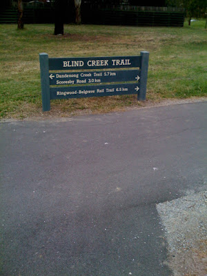
Another one without any mention of the Stud Road Trail, at the southern intersection of the Blind Creek Trail and the Stud Road Trail.
This is at the intersection of the Burwood Highway Trail on the northern side of Burwood Highway. The holes have been dug but no sign here yet.
Now, this sign is my favourite blooper. First of all, they put the sign in a spot where nobody riding on the Blind Creek Trail will read it, it is on the Burwood Highway Trail on the southern side of Burwood Highway instead. No mention of the Burwood Highway Trail, but amazingly, THERE IS A MENTION OF THE STUD ROAD TRAIL!!! These signs boggle the mind!
Eastern side of the Timothy Drive underpass.
Western side of the Timothy Drive underpass.
Strange setup here at the small link trail to Renou Road between High Street Road and Timothy Drive with the metal handrail obscuring the sign somewhat, but I guess there is not much choice of where to put it here!
Sign at the small link trail to Cathies Lane.
Sign at the small link trail to High Street Road on the northern side. Jells Park should have been included on this sign in my opinion.
Shockingly placed sign which makes it look like the trail runs on the southern side of High Street Road (the trail going off to the left of the pic) instead of going past where the photographer is standing.
The back of the same sign as above, facing open grass where nobody will read it, let alone know that there are directions on this side! This intersection needed a 2 sign setup here.
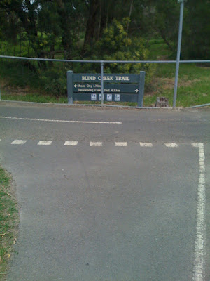
This sign was installed when the EastLink Trail opened, and was the first Blind Creek Trail directional signage installed. This sign was installed by EastLink, while the other signs featured were installed by Knox City Council.
The sign has the directional arrows next to the title which should be standard on all signs, as I mentioned above, but this intersection needed a 2 sign setup. One sign does not cover all directions and destinations, especially at such an important intersection.
Thats all for now! If they have been installed, I will post up pics of any new signs that have been installed around my area, along with my gruelling commentary!

Saturday, October 18, 2008

Blind Creek Trail now receiving directional signage!


I'm pumped about this. I rode west along High Street Road to travel on the EastLink Trail today and I noticed to my surprise that the Blind Creek Trail now has 3 directional signs around the Cathies Lane / High Street Road intersection. Now, Knox City Council said they were going to quickly implement directional signage, as they highlighted the lack of signage as a major factor contributing to cyclists not using the Knox City Council shared paths. I hope this is the start of the large signage installation program and I hope to see more signs along knox bike tracks in the near future. As long as they have the right names (e.g. "Belgrave Rail Trail" and "Stud Road Trail" instead of things along the lines of "Oppy Trail"), because a trail name has to reflect the Geographic characteristics of an area, such as a major park, precinct, creek/river or road.

Myself and many others have always regarded Knox City Council to be one of the most cycling friendly councils in Victoria, due to the fact that there are about 80-90km of trails which lie within or on the border of Knox, which makes some very good cycling circuits (The Dandenong Creek Trail / EastLink Trail / Blind Creek Trail / Belgrave Rail Trail is an excellent cycling loop, taking in the top half of Knox), but they were a pain to navigate. You would have to look at the Melways or OpenCycleMap and other websites first to find out where to go so you don't get lost. Go Knox Council! Keep up the great work!


Look at the Bicycle Victoria page on Knox City Council for some information on the cycling related projects being put forward as well a a link to the latest Knox Council bicycle plan.

Saturday, October 11, 2008

My experience with the Main Yarra Trail


Today I decided to ride a trail which I have never been on before.

The Main Yarra Trail is one of Melbourne's major trails, and one of the most popular.

Starting from Docklands/Port Melbourne and sneaking it's way past the CUB brewery, the Fairfield Boathouse, along the Eastern Freeway and through Westerfolds Park before ending in Templestowe at an unsigned intersection with the Mullum Mullum Creek Trail. I have always felt that the trail should be named in align with other trails, as the "Yarra River Trail", but I guess the "main" name is suitable for it, as it provides connections for a number of trails including the Capital City Trail, Sandridge Rail Trail, Gardiners Creek Trail, Merri Creek Trail, Outer Circle Rail Trail, Koonung Creek Trail, River Gum Walk Trail, Plenty River Trail, Ruffey Creek Trail, Diamond Creek Trail before finally ending at the Mullum Mullum Creek Trail.

For a trail with so many connections, the trail is currently insufficient in many ways including alignments, signage, line marking and surfaces. A trail of this importance should have high priority over what works should be done to it. It is simply not good enough at the moment.

I tried to navigate the trail today by simply following whatever signage had been installed over the trail and I was lucky I brough my iPhone 3G with the built-in GPS, which saved me having to go down a trail only to find out that it did not take me to where I wanted to go.

I rode from the very end of the trail at the Mullum Mullum Creek Trail to the turnoff under the Eastern Freeway today, and I will highlight the major issues I have with this trail.

  • Signage: The signage along the trail is very sub-standard. Signs are very rare to find along this section of trail, especially between Westerfolds Park and Heidelberg, in which there were some very confusing intersections which can easily lead a casual rider astray, especially at a couple of locations where there is a Y fork in front of you with the option of taking a sealed path or a gravel path. Naturally, you would follow the sealed path you were already riding on, while the path you were susposed to go down was the gravel one. I'm also amazed I could get myself through Westerfolds Park via the 2 or 3 "Main Yarra Trail" signs which I encountered.
  • Alignments: There are a couple of sections where the entire trail needs to be re-routed to give a more direct path and a couple of spots where the alignment should be re-constructed altogether. In Banyule Flats Reserve is the major headache. You can either follow the official trail, which is 1.56km long, or take the fairly level (hardly any hills) goat track shortcut which is only 0.76km long, less than half the official trail. There is also the underpass under Banksia Street in Heidelberg, which is shockingly designed on the northern side of the bridge. Not only is the path in a shocking condition, going south under the bridge was a nightmare, with my brakes on, I felt like i was going to flip over the handlebars. This needs to be fixed quick smart.
  • Surfaces: The ideal shared path surface has always been asphalt, which is nice to ride on, but sometimes cracks can very easily surface, and grass gets in the cracks therefore damaging the trail. Concrete is the way of the future for all trails, despite some trails still being built with asphalt. For the best example of a fantastic trail with a concrete surface, ride the EastLink Trail if you haven't already. One gripe I have about some sections of a trail is the unnecessary gradients. Some spare dirt can easily be piled on top of an existing trail, then concreted on the top to avoid high inclines. This can easily be a great incentive to get more users on the trail. Remember that research done by Bicycle Victoria shows that sealed paths generate much more usage than gravel or natural earth paths.
  • Line Marking: On all sealed routes, line marking is very important. It establishes where the trail should go. No line marking can easily lead to riders going on the wrong trail. People who go out riding without looking at cycle maps (look at the OpenCycleMap for Melbourne (you can help build it, it uses the OpenStreetMap database) http://www.opencyclemap.org/?zoom=11&lat=-37.85185&lon=145.0334&layers=B000), can easily get lost. Brilliant intersection signage along with road-style line markings give the rider much more confidence that they are going the right way.

    Thats all for now! I let alot off my chest with this post and how the Main Yarra Trail really needs to live up to it's name. Feel free to comment on any of the points in what I have written.

Thursday, October 9, 2008

First post on the Melbourne Bike Routes blog!

Welcome to the Melbourne Bike Routes blog. My name is Luke W and I will keep this blog updated with news and reviews of Melbourne's bicycle network. If a new path I know about is under construction or opening, I will keep you updated. I will also express my thoughts on the state of parts of the bicycle network which can be easily improved, in such ways as better signage, line markings and realignments, in a hope to raise awareness of these issues and get a step closer to these problems being fixed.

Feel free to contact me with any news or suggestions by posting comments. Thank you.

My first image is of the Dandenong Creek Trail / EastLink Trail running through southern Koomba Park. Ever since this hugely popular section of the gravel Dandenong Creek Trail was upgraded, visitor numbers to Koomba Park have definitely jumped thats for sure!